It is not often that satellite imagery feels personal.
For most people, images captured from space belong to a distant world of science and data. They are used to study forests, track floods, monitor cities and measure change. They are precise, detailed and important, but rarely something an ordinary user pauses to explore.
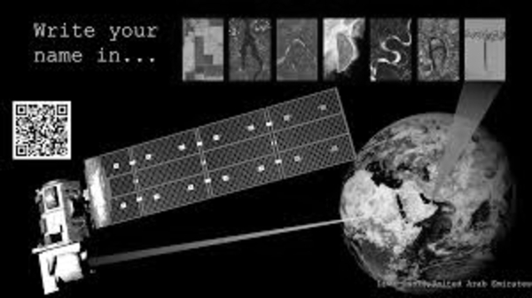
That changes, even if briefly, with a simple Earth Day tool built using the Landsat Program.
The idea is uncomplicated. A user types a name into a search box. Within seconds, the name appears on screen. But instead of standard text, each letter is formed from real images of the Earth. A winding river might resemble an “S”. A stretch of coastline might shape an “L”. A patch of desert or farmland might complete another letter.
Each character is sourced from a different part of the world. Nothing is designed or artificially created. The shapes already exist in nature. The tool simply finds them and brings them together.
At one level, it is a small digital activity. It takes a few seconds, requires no explanation and asks for nothing more than a word.
At another level, it reflects a quiet shift in how people interact with complex information.
Satellite imagery has long been associated with expertise. It is something scientists analyse, governments rely on and researchers interpret. For the average user, it can feel abstract, even inaccessible. The scale is vast and the purpose is often technical.
This tool changes that relationship, not by simplifying the science, but by changing the entry point.
It begins with something familiar. A name.
That familiarity creates a moment of recognition. Instead of looking at anonymous patterns on a map, the user sees something personal. The image is no longer just land or water. It becomes part of a word they identify with.
The experience is brief, but it leaves an impression.
Some users try it once and move on. Others return to it, entering names of family members, friends or places that matter to them. Each result is slightly different. Because the letters are drawn from different landscapes, no two outputs feel exactly the same.
In that process, something subtle happens. Users begin to notice details they might otherwise overlook. The curve of a river, the outline of a coastline, the texture of land seen from above. These are not new features. They have always existed. But they are now seen with a different kind of attention.
The tool was introduced as part of Earth Day outreach. Its purpose is not to teach technical concepts or explain satellite systems in detail. Instead, it offers a simple way to engage with Earth observation.
There are no instructions to follow, no data to interpret, no complexity to manage.
That simplicity is central to its impact.
In recent years, large datasets have become more accessible, but accessibility does not always translate into understanding. Information can still feel distant if it is not presented in a way that connects with everyday experience.
This tool addresses that gap in a modest way. It does not attempt to explain everything. It does not overwhelm the user with detail. It offers a small point of connection and leaves the rest open.
The significance of that approach is easy to overlook.
In journalism and public communication, there is often a focus on scale and importance. Large developments, major discoveries and significant changes tend to dominate attention. Smaller efforts, especially those designed for engagement rather than information, can appear less critical.
Yet, it is often these small, accessible entry points that shape how people relate to larger ideas.
By turning satellite imagery into something interactive, the tool invites curiosity. It encourages users to look again, even if only for a moment. It suggests that the Earth, in all its scale and complexity, is not entirely out of reach.
There is no dramatic message attached to it. No direct call to action.
The takeaway is quieter.The images remain the same. The science behind them does not change. The satellites continue to orbit, capturing data as they have for decades.
What changes is perspective: For a few seconds, a user sees their own name reflected in patterns that exist across the planet. It is a small interaction, but one that brings distant imagery closer to everyday experience.
And in that brief moment, something technical becomes familiar.